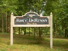
Friends of Fort DeRussy, Inc.
The Official Site of Fort DeRussy, Louisiana
Fort DeRussy News
Issue 7 June 2001
Long-
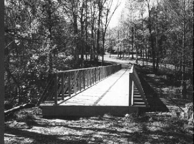
Only railings, fencing remain to be attached
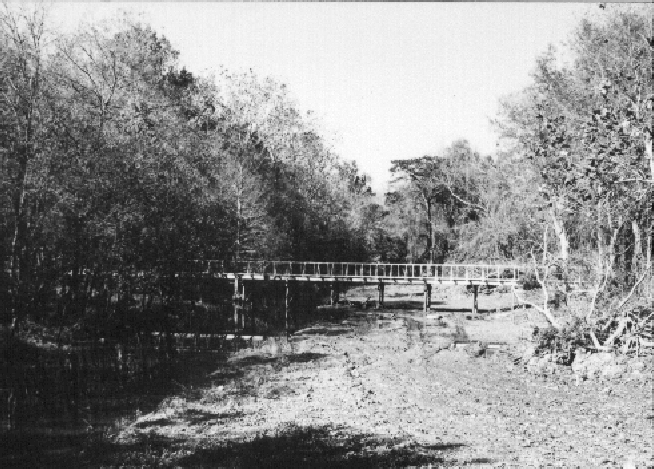
One of the most distinctive features on Civil War era maps of Fort DeRussy is the bridge the crossed the bayou in front of the fort, connecting the fort to the covered way that ran down to the water batteries. A recently discovered map shows that the bayou at that point was twenty feet deep during high water, so a substantial bridge was necessary. A proposal to rebuild the bridge was first made in 1998, but other activities took priority until after the turnover of the fort to State Parks.
With the turnover completed, it became necessary to spend the funds remaining in the City of Marksville’s Fort DeRussy Fund. The Office of State Parks was given a set of possible ways that the money could be spent, and it was at their recommendation that plans to rebuild the bridge began in earnest.
The Avoyelles Parish Police Jury agreed on March 14, 2000, to provide manpower and equipment to build the bridge. Bid sheets went out in August, and the low bid came in from Druco Lumber of Mansura, LA. Construction began in September, and the pilings were completed and decking laid down by early November. A crew of prisoners from Avoyelles Correctional Center came out in December and nailed down the decking and put up handrails. Fencing (a state requirement) and additional railings will be added at a later date.
For additional stories on the building of the bridge and the spending of the state money, see articles on pages 2 and 4.
Building The Bridge
Just how hard can it be to build a Civil War era bridge across a thirty-
Construction began on Tuesday, September 19, 2000, and we ran into our first roadblock on the 20th. The Police Jury piledriver bogged in the mud on the bayou bank, and lost its drive shaft while being pulled out. Merrick Construction of Cottonport came to the rescue with mats for the bayou bank, and the Red River, Atchafalaya, and Bayou Boeuf Levee Board provided a tracked dragline to replace the wheeled piledriver. The Police Jury bridge crew was back at work on Monday, reinforced by the Levee Board dragline crew. David Boyd, the fort’s chief engineer, must have looked down jealously as he saw the dragline, bulldozers, and trucks loaded with pilings and decking on the site. He had had nothing but problems during his tenure as chief engineer, shortages of supplies and manpower being severe. I, on the other hand, had more horsepower available than Boyd could have dreamed of.
He must have laughed uproariously, and I nearly cried, when on Tuesday, October 3, I came to examine the completed pilings with capsills in place, and found that the bridge was going to be two feet too low when completed! I now had a bridge that was going to go underwater at least once a year, unless modifications were made.
There was nothing to do but order more capsills, to put two capsills on top of the pilings instead of the planned one. That raised the level of the bridge enough that it is now expected to go underwater only once every ten years or so. But it added considerably to the cost, as well as to the time involved. By Friday, November 3, the Police Jury workers had finished their part of the bridge. While there were no handrails and the decking was not nailed down, the bridge was useable in time for the HistoryAmerica Red River Campaign tour that Saturday.
Decking and handrails were put up in December by a work crew from Avoyelles Correctional Facility, capably led by Sgt. Gene Brouillette, Jr. The men used building techniques typical of the 1860’s (OK, they did cheat a little and used a pneumatic nail driver), resulting in a bridge that authentically reproduces the bridge it replaces.
Special thanks go out to the Police Jury, Levee Board, Merrick Construction, AVC road crew, and Nolan Bordelon, all of whose assistance was critical to the proper completion of this bridge.
The completed bridge, seven feet wide and 186 feet long. The approaches have not been completed, in order to keep off unauthorized traffic. This view is from the river side, looking toward the fort.
Another view of the bridge, from the Fort DeRussy Road bridge, looking north up Bayou Barbin. The water in the bayou is about two feet deep in this picture. In the 1860’s, it would have been eight feet deeper at this same level. The levee system has resulted in the silting up of the bayou.
DeRussy Funeral Featured
The reburial of Lewis DeRussy, which took place at the fort on September 26, 1999,
was featured in a segment of Louisiana Public Broadcasting’s “Lost Louisiana” series.
The funeral was originally supposed to be aired earlier in the episode concerning
Red River, but was cut from there because of time constraints. (The popular series
aired during a donation appeals week, so the one-
Maps Located
Several “new” maps of Fort DeRussy have been located since the last newsletter went to press.
The Jeremy Gilmer collection (Gilmer was Chief Engineer of the Confederate Army)
at the library of the University of North Carolina-
Tad Britt, formerly with the US Corps of Engineers at Vicksburg, delivered an 1892 COE map of the Red River at the fort to Marc Dupuy, Jr. This map shows the remains of the water battery as they existed some 28 years after the war. Another section of this same series of maps shows the remains of the Confederate Dam at Saline Point. These maps, when compared with current maps, will allow for surface location of these features (both the water battery and dam locations have been lost over the years).
A third, and even more remarkable, find is the sketch of the area surrounding the fort as it was at the time of the May 4, 1863 Gunboat Fight. The original drawing has been hanging on a wall in the Spring Street Historical Museum in Shreveport, LA, for some 20 years. It was donated anonymously in 1979, and is not signed, so the artist is unknown. However, the details shown in the sketch indicate that the artist was intimately familiar with the boats involved in the fight, as well as the surrounding countryside. The sketch agrees with other known maps of the area from that time period, and also gives details concerning the homes in the area, locations of outbuildings and fences, as well as the rather unusual appearance of some of the boats involved in the shootout (in which one US sailor, James Brown – no relation to “the hardest working man in show business” – won a Medal of Honor.) This sketch was noticed and reported to Friends of Fort DeRussy by Duke Rivet of the Louisiana Division of Archeology.
There is a lot yet to be learned about the history of Fort DeRussy, and we ask that anyone locating items pertaining to the fort please notify us. There are undoubtedly other maps out there yet to be found.
FFD Chairman Receives Avoyellean Award
In appreciation for five years spent spear-
Burial Flag Donated
At their February 6, 2001, meeting, the Alexandria, LA chapter of the Sons of Confederate
Veterans presented one of the flags that covered the coffin of Lewis DeRussy to the
Friends of Fort DeRussy. The flag is now included in the items being collected for
the Fort DeRussy museum. It is one of three flags that were laid on the General’s
coffin at various times during the wake and funeral. The other two are currently
in possession of the Sons of Confederate Veterans and one of DeRussy’s great-
Editorial
Money well spent? We think so.
In 1997, the State of Louisiana gave $75,000 to the City of Marksville to be spent on Fort DeRussy. The spending of this money was administered by Friends of Fort DeRussy. Over the years, I have heard from several people who were philosophically opposed to the State’s providing us with this money. Well, the money is all gone now. Here is a rough breakdown on where it went. You can decide for yourself whether or not the money was well spent.
For their $75,000, the State of Louisiana got:
A new state historic site
70 acres of property
A really nice entrance sign
A 186-
Three granite monuments (one small, two large)
The grave of Lewis DeRussy
Picket fence around a historic cemetery
Library collection (over $7,000 value, including documents available nowhere else in the state)
Assorted museum artifacts
$70,000 grant from US government
All of this was not actually bought with the State’s money. But with the State money, we were able to obtain the additional grants necessary to do the above. There are also a lot of improvements to the property that don’t show in the above list. And how do you put a value on a preserved historic site of this magnitude, or on the publicity that has been generated for the fort?
All in all, I think we can be pretty proud of the way we spent the State’s money. It would be an impossibility for any governmental agency to have accomplished as much with the same amount of money. The State money would not have begun to cover the wages necessary to pay for all of the free time and labor that was donated to making Fort DeRussy what it is now. And the fact is, no governmental agency – Federal, State, or local – was willing to take on the job. They all helped whenever asked, and for that we are grateful. But the Friends of Fort DeRussy led the charge. So Thank You, too.
The money is gone now. But anyone who thinks it was wasted will have a hard argument to make.
State Parks
Turning an old Civil War fort into a working State Historic Site is a much more difficult job than one would imagine. And it takes a long time.
That was the gist of the message given to FFD by Office of State Parks personnel
in meetings held in Baton Rouge this past March. But while the time frame for a full-
In future newsletters, the Office of State Parks will be invited to contribute a column, written by themselves, so that your editor will not be paraphrasing them.
Adjustments and Corrections
In our last newsletter, we neglected to mention that the $70,000 Land and Water Conservation Fund Grant received was due in large part to assistance from the Civil War Preservation Trust.
Reenactments Continue
2002 reenactment to take place on site
The Second Annual Battle of Fort DeRussy was nearly flooded out due to high water in the Red, but quick action and incredible flexibility on the part of the reenactors and property owners led to another fine performance, this time on the protected side of the levee. A March cold front made coats mandatory wear for spectators.
Currently, plans for the 2002 reenactment call for a cooperative event, sponsored by the LA Office of State Parks and the Cenla Historical Reenactment Group, to be held on the grounds of the fort. The time for the battle has been changed from March to October, which should allow for better weather and fewer conflicts with other reenactments. Everyone is encouraged to attend the next reenactment in October, 2002.